Transport for Cairo (TfC)
Short Description: Transport for Cairo ’TfC’ is an Egyptian action research lab mapping formal and informal urban transport reimagining them as networks.
Description: Transport for Cairo ’TfC’ is an Egyptian action research lab reimagining existing transport networks to improve accessibility. We are mapping Cairo’s formal and informal transit networks to create better information for planning and improved passenger information services. Our team brings together the best of the information, urban and transportation worlds together to ensure that over the coming years congestion does not destroy our cities. Committed to openness, we directly and indirectly improve public service transit provision, ease moving around our cities using technology and produce actionable research that can be implemented to ensure sustainable future mobility.
The TfC urban mobility lab is the heart of the Research & Development performed by TfC. Mapping urban mobility refers to collecting geographic data on routes, stops and building a record of stop names, stop infrastructure, interchanges and route pricing. A more advanced level of mapping covers temporal data to include data collection on service frequencies, service operating times, and creation of estimated timetables incorporating expected trip durations according to road traffic conditions by relying on Big Data API’s. This data is then translated into the industry standard GTFS format, enabling advanced analytics and trip routing. A second strand of R&D focuses on the adequacy of urban transport systems, performing qualitative research to understand underlying dynamics as well as consumer preferences and behavior.
Place for experimentation : Cairo
Map (on development) :Web Site: http://transportforcairo.com/
Organisations involved in the project: Transport for Cairo (TfC), Digital Matatus Team, Takween for Integrated Community Development, Expo Live
Organisation interested to participate / use deliverables:
Contributors (people): HEGAZY Mohamed, KALILA Adham, GABER Islam, HEGAZY Abdelrahman
Tags: Cairo, GTFS, Paratransit, Semi-formal, schedule estimation
Theme: Accessibilité dans les transports, Données ouvertes, Traces de mobilité et des données associées, Urbanisme et ville, Conseillers en mobilité, Collectivité, Africa
Referent (people):
Challenge associated to your project : Augmenter les connaissances partagées en cartographie et usages des véhicules et réseaux de transports
Common(s) used:QGIS, R, Google MyMaps
Common(s) produced: GIS Data, GTFS feed, Paper Transit Maps, Policy Papers, Consultancy work, Capacity Building
Linked Communauty of interest: Communauté Cartographie Contributive, Communauté autour des données ouvertes
Advisor, mentor useful for the project:
Project deliverables: Available & Validated
Digital space for discussion (mailing list):
Chat for direct discussion:
Trello for actions:
Digital space to share files (drive, wiki, etc...): https://git.digitaltransport4africa.org/cities/cairo
Needs identified:
Complements:
Next step:
Others informations:
Phases of the project[modifier | modifier le wikicode]
Cities are engines of art, business, science and progress; domains which are challenged by traffic, smog, inadequate and inequitable transport services and unplanned urban sprawl. Rates of private motorization are still increasing in developing countries further worsening congestion, air quality and social disparities. The basic problem to solve is how to provide the most sustainable transport option to maximize accessibility across society while minimizing transport’s negative externalities.
In 2015, a group of Egyptian youths decided to volunteer together in an attempt to address the escalating problem of traffic congestion through a technological approach. This group encompassed a diverse array of disciplines spanning economics, urban research, transportation engineering and information technology - coming from non-profit, for-profit and government backgrounds. They decided to found and manage a new dedicated action research lab - named ‘Transport for Cairo’ or ‘TfC’ - with the objective of creating transit data, keeping it maintained and utilizing it to improve mobility and accessibility in Cairo.
In 2016, Takween for Integrated Community Development and Transport for Cairo formed a joint consortium to respond to the urban transport policy challenge by mapping the formal and para-transit networks of the GCR to create a comprehensive dataset on all existing transport options for commuters, translate that data into the industry standard GTFS format, and test whether the data collected could be expanded to include measures of adequate mobility allowing the calculation of accessibility indices and breaking them down by different target segments across gender, age and other personal differentiators. This TICD-TfC consortium was soon expanded to be DM-TICD-TfC, with the welcome addition of Digital Matatus, adding an experienced partner and international dimension to tackling the para-transit policy gap.
With support from the Expo Live Innovation Impact Grant Programme, the newly formed DM-TICD-TfC consortium set out to map all modes of transit operating within the Greater Cairo Region as part of a project called Digital Cairo stretched over two years. Through the funded first phase of Digital Cairo, Transport for Cairo collected basic route and system adequacy data using mobile devices for 216 bus routes.
The project is divided in multiple phases:
- Phase 0 (2015-2017): Research & Development, Conceptualizing Adequate Urban Mobility
- Phase 1 (2017-2018): Data Collection of all public transport services originating and ending within six New Desert Cities within the Greater Cairo region.
- Phase 2 (2018-2019): Data collection of all public transport services serving inner city Cairo.
Throughout the project, the DM-TICD-TfC consortium is engaging in a local and global debate on addressing the urban mobility challenge and working systematically towards achieving adequate urban mobiltiy.
Phase 0[modifier | modifier le wikicode]
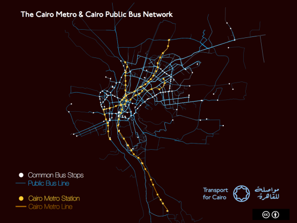
The team began by collecting the data of the metro line (1, 2 and 3) and approached several institutions to recover existing datasets. The World Bank had created basic traces of bus lines. Using these, the TfC team spent 3 weeks crowdsourcing pictures and photographing buses on Cairo’s streets using smartphones. By the end, 750 pictures identified 227 unique buses on Cairo’s streets. Next, all the pictures were cross-referenced based on location with city government and World Bank data using purpose-built software to verify bus routes. The most accurate 20 routes were chosen and put in a usable format – specifically GTFS. Official stations as written on buses were chosen to denote where buses stop.
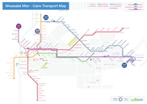
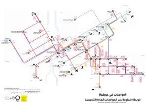
Those data was shared and the used by Desert City Mappers and Transport for Cairo (TfC) on collaborative workshop organized at MSA University, Cairo, titled “Transit Map Design”. The 3-day workshop included Students from Cairo’s Public and Private Universities, and involved visualizing 20 bus lines in order to design a schematic map of this network.
Phase 1 & 2[modifier | modifier le wikicode]
Identification Phase[modifier | modifier le wikicode]
Before begining the data collection, they had a strong phase of identification and improvement of the processus. Considerating the scale of the city and the quantity of data that should be collected, the team decided to firstly focus on the case of dessert cities.
Data Collection[modifier | modifier le wikicode]
Before beginig the data collection, they had a strong phase of identification and improvement of the processus. The aim of their project was to provide some exhausted data to inform the service users about the mobility services provides by both formal and informal system and to focus on both component: geographic and temporal data. As the geographic data collection process has been succefully driven by both experience in Accra and Nairobi, they decided to focus on improving the modelisation and the estimation of schedules for each bus and mini-bus, even if they don't follow a strict schedule. Firstly, they made an estimation: A bus leave the terminus every 3 minutes. Then, they collected the usual on-board data by using TransitWand App like stops and routes but they also collected the speed average for each lines and the time between each stop. They made a peak and an off-peak data collect for each stop and they were able to estimate the arrival time at each stop and to provide some estimated schedule for each bus lines.
Data processing and communication[modifier | modifier le wikicode]
The team worked on developping a set of internal tools to automate the cleaning process of triped collected and the steps to create a GTFS feed. The data collected are available here for the metro lines and the Phase 1 data's are estimated to be available on summer 2018.
Links[modifier | modifier le wikicode]
GTFS
Map
Papers
Pilote Project Overview
Other languages : ![]() English -
English - ![]() Français
Français


 Français
 English
 Italiano