PTMap
Short Description: OSM public transport viewer.
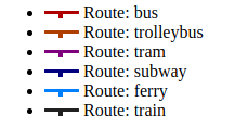
Description: The PTMap shows public transport routes as they are entered to the OpenStreetMap. As there is no timetable data added to the OpenStreetMap, this information can not be available. Anyhow, the operating hours are respected, so you can play with the date/time to show routes at different days resp. times of day (see below for more information).
Web Site : https://ptmap.plepe.at/#lat=49.30770&lon=3.68610&zoom=14
Organisations interested to contribute or already contributing:
Organisations using or interested to use the resource:
Contributor:
Tags: osm, public-transport, vieillesse, viewer
Category: Logiciel
Theme: Open Street Map OSM
Referent:
Challenge addressed:
Key persons:
Other common:
Communauty of interest:
Type of common:
Produced in the field of OpenChallenge?
Level of developpment
Chat Space to discuss: [1]
Mailing list:
Task management link:
File management link:
Needs:
Complement:
Next step:
Others informations:

 Français
 English
 Italiano