Mapa dos Chapas
Short Description: Project of maping services provide by Chapas in Maputo
Description:
In Maputo, the public passenger transport services is provided principally by small private sector operators. They are using vehicles known as Chapas, mostly 15 and 25-seat minibuses or mini vans.
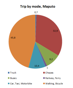
In 2014, the number of Chapas was estimated to 4.500 vehicules, operating along 130 routes and almost 60% of motorized trip were made by using Chapas.
Some transit densification project like:
- a BRT in Maputo
- a LRT to connect Maputo and Matola
are under reflexion and the aim of the present project was to map the informal transit system in order to develop those mode in a more suitable and equitable manner.
The experience was drove by The Chapas Crew with the help of different actors like Waza and UCL. They also receive a financial help from The Kestrelman Trust, the Dialogo Program (Dfid), the AGIR program (Swedish Embassy) and the Rosa Luxemburgo Fundation.
Place for experimentation : Maputo, Mozambique
Map (on development) :Web Site: https://chapasproject.wordpress.com/
Organisations involved in the project: Chapas Crew, Waza, UCL Project, DFID, AGIR Program, University College of London, Transport Department of the Maputo City Council
Organisation interested to participate / use deliverables: Maputo City Council, Atromap, Athmap, Asoctra, Public Bus Operator (MTP)
Contributors (people): CAVOLI Clemence
Tags:
Theme: Open Street Map OSM, Traces de mobilité et des données associées, Africa
Referent (people): Joaquín Romero de Tejada, CAVOLI Clemence
Challenge associated to your project : Augmenter les connaissances partagées en cartographie et usages des véhicules et réseaux de transports
Common(s) used:OpenStreetMap
Common(s) produced: Mapa dos Chapas
Linked Communauty of interest: Communauté Cartographie Contributive, Communauté autour des données ouvertes, Communauté autour des traces de mobilité et des données associées
Advisor, mentor useful for the project:
Project deliverables: Available & Validated
Digital space for discussion (mailing list):
Chat for direct discussion:
Trello for actions:
Digital space to share files (drive, wiki, etc...): https://git.digitaltransport4africa.org/cities/managua
Needs identified:
Complements:
Next step:
- Transcribe the map into digital format
- Expand the map to cover the metropolitan area
- Establish physical bus stops
Others informations:
Introduction[modifier | modifier le wikicode]
This project has been developped to map Chapas of Maputo and to initiate a dialogue with paratransit stakeholders .
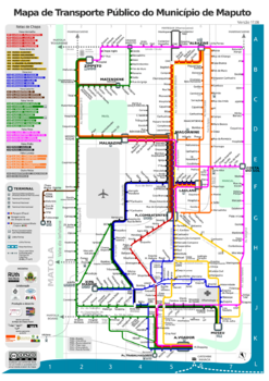
The aim of the project was to implement a regular map of the Chapas' network in order to highlight and promote this transport mode. Mapa dos Chapas team aims to provide visibility and recognition to the informal sector with public authorities. Indeed, local authorities are currently focus on main infrastructure projects and dialogue with paratransit sector is critical for its integration with the upcoming BRT.
Mapping Process[modifier | modifier le wikicode]
Firstly, they localize minibus lines and stops by using smartphone. They collected data upon minibuses network.
Secondly, they organised a workshop with all the minibus operators and the public authorities to name the bus stops and to confirm the data (stop location, line). The stop's name depends on the Landmark, for example the name of the restaurant next to the stop.
Once all the data has been collected and their quality ensure, they design a schematic map that they published and they updated the map (version 2) after receiving the feedback from users.They are using the graphic's codes that are usual for tube maps
Finally, they also add those data to the OSM Transport Map
Outputs of the project[modifier | modifier le wikicode]
The project was a success, the local authority asked whether the map could include other modes like rail and public bus lines and they made it official. It has become the first and official map of public transport in Maputo. It has also stimulated the dialogue between the different stakeholders and it gave visibility to paratransit.
But the team has identified an unexpected output : The officialization of bus stops. Collaborative mapping led to a process of formal recognition of bus stops. Previously bus stops were based on social agreement, the majority of the bus stops were not formally recognised by the local authority – led to a project with Architects without borders to build bus stops.


 Français
 English
 Italiano